
In his 1961 book, Megalopolis: the Urbanized Northeastern Seaboard of the United States, geographer Jean Gottman adopted the Greek term “megalopolis” to refer to the vast conurbations of the northeastern seaboard of the United States from Boston to Washington DC (later dubbed BosWash by futurist Herman Kahn).[1] Gottman considered megalopolis “the cradle of a new order in the organization of inhabited space.”[2] But even though megalopolis was—and remains—the densest part of North America, this new form of inhabited space is not an unrelating city, rather it is primarily suburban, punctuated by both urban centers and interstitial areas. Flying over BosWash, Gottman observed that,
behind the ribbons of densely occupied land along the principal arteries of traffic, and in between the clusters of suburbs around the old urban centers, there still remain large areas covered with woods and brush alternating with some carefully cultivated patches of farmland. These green spaces, however, when inspected at closer range, appear stuffed with a loose but immense scattering of buildings, most of them residential but some of industrial character. That is, many of these sections that look rural actually function as suburbs in the orbit of some city’s downtown.[3]

Today, the megapolis has spread worldwide, both in terms of the numbers of giant conurbations worldwide and in terms of their physical size and populations. But what of the green areas Gottman mentions? Some of these, of course, are still farmland, serving to provide residents of the megalopolis with the freshest possible produce from artisanal farms, much more expensive to grow and purchase than the usual fare from industrial agriculture on distant, less valuable land. Other areas, frequently woodland, are used for dispersed exurban living. But any megalopolitan region is also marked by large areas that appear to have been left vacant. While some have been designated parkland or nature preserves, others are examples of what, in 1995, Ignasi de Solà-Morales called “Terrain Vague,” leftover spaces in the urban realm, places in which something has taken place but now have become abandoned.[4] For Sola-Morales “the relationship between the absence of use, of activity, and the sense of freedom, of expectancy, is fundamental to understanding the evocative potential of the city’s terrains vague. Void, absence, and yet also as promise, as encounter, as the space of the possible.”[5]

Critically, Solà-Morales approaches the terrain vague not in terms of architecture or urbanism, but rather in terms of photography. He continues:
The triple signification of the French vague as ‘wave,’ ‘vacant,’ and ‘vague’ appears in a multitude of photographic images. Recent photographers, from John Davies to David Plowden, Thomas Struth to Jannes Linders, Manolo Laguillo to Olivio Barbieri, have captured the condition of these spaces as internal to the city yet external to its everyday use. In these apparently forgotten places, the memory of the past seems to predominate over the present. Here only a few residual values survive, despite the total disaffection from the activity of the city. These strange places exist outside the city’s effective circuits and productive structures. From the economic point of view, industrial areas, railway stations, ports, unsafe residential neighborhoods, and contaminated places are where the city is no longer.
Unincorporated margins, interior islands void of activity, oversights, these areas are simply un-inhabited, un-safe, un-productive. In short, they are foreign to the urban system, mentally exterior in the physical interior of the city, its negative image, as much a critique as a possible alternative.[6]

For Solà-Morales terrains vague have evocative potential because they are undeveloped, because they are un-productive, revealing our anxieties about the urban realm at precisely the late capitalist time when the world is becoming thoroughly urban. The end of Solà-Morales’s brief text is harder to parse, but seems framed to appeal to his host Peter Eisenman, Rem Koolhaas and the other deconstructivist architects of the day, suggesting that architects can intervene in the terrain vague by finding ways to express “the flows, the energies, the rhythms established by the passing of time and the loss of limits … continuity in contrast to the clarity and distinctness with which the strange world presents itself.”[7] Unfortunately, such language could mean more or less anything and Solà-Morales’s text was swiftly co-opted by architects for whom terrains vagues served as sites upon which bold new shapes would rise. Lots made vacant by wartime bombing, urban decay, or industrial contamination are now glittering monuments to capital in the form of luxury housing, shopping centers, or office parks.

If designing for terrains vague has proven to be a failure, in this project, I set out to return to the most dangerous provocation of Solà-Morales’s text, that terrains vague might be most provocative if left as is, that the terrain vague is best explored through the medium of photography. Given the limitations that the pandemic set on our own travels in 2021, my research possibilities were limited. I set out to investigate areas within the metropolitan area of New York City that I could easily drive to from my house. But rather than forcing a compromise, this reminded me of how Robert Smithson, who grew up in this area, later explored it in essays such as “The Crystal Land” and “A Tour of the Monuments of Passaic New Jersey,” and particularly in how he sought to understand human time as an aspect of geological time.[8] This understanding was given a scientific underpinning with the identification of the new geological epoch of the Anthropocene in the May 2000 issue of the International Geosphere-Biosphere Programme’s newsletter, “Global Change.” As meteorologist Paul J. Crutzen and biologist Eugene F. Stoermer explain, in this epoch, humanity’s effects on the planet—mainly in terms of rising amounts of greenhouse gasses—have become more clearly visible in the geological record.[9] Even if we lament our impact, we are part of the geological system now, and even ecological restoration is an anthropogenic intervention.
Having acquired a rare, frail copy of Henry Barnard Kümmel’s doctoral dissertation, Lake Passaic: An Extinct Glacial Lake, I found myself looking at a conglomerate of interstitial spaces in the northeast American megalopolis composed of swamp comprising roughly one-quarter of Essex County, New Jersey, the densest county of the densest state in the United States.

The area’s geological conditions, critical for this project, can be described as follows. First, the area’s northwest boundary is set by the New Jersey Highlands, stubs of igneous mountains that arose during the Precambrian era, part of the billion-year-old Grenville Orogeny that stretches from the southeastern United States into Canada. This mountain-building event took place unseen by any living thing; life had not yet appeared on land and neither plants nor animals had evolved out of the early microbes that lived in the water. A shallow sea lay to the south and east and as the mountains eroded over subsequent eras, rivers carried clay, silt, and sand down to the sea, building up a vast delta that now forms most of eastern New Jersey. That low delta is considered part of the Piedmont lowlands that, follow the eastern boundary of the Grenville Orogeny, extending from New Jersey’s northern border with New York to the state of Alabama.[10]
Africa, for some of this time, had been located immediately southwest of present-day New York City, but about 180 million years ago, during the Jurassic era, it pulled away and, in so doing tore rifts in the earth’s crust which in turn released vast amounts of lava that built three low ridges running from the northeast to the southwest known as the Watchung Mountains. Finally, during the last glacial period, between 22,000 and 18,000 years ago, the Wisconsinan Glacier covering North America dumped its terminal moraine across the south end of the basin formed by the Highlands and the first Watchung Mountain. As the glacier continued to retreat, a basin was formed by the Highlands to the West, the Watchung Mountains to the East, the terminal moraine to the South, and the glacier itself to the north. With water unable to escape, glacial meltwater filled the basin, turning it into a massive lake some 45 kilometers long, 15 kilometers wide and 150 meters in depth. The lake existed for 1,500 years until a gap in the First Mountain opened up at what is now Great Notch, producing the Great Falls in Paterson, New Jersey. Even after that, postglacial lakes persisted in the area for 3,000 to 4,000 more years until they finally drained out into the Passaic River.[11]

The Passaic River still drains through the Great Fall, but the entire basin which Glacial Lake Passaic filled remains influenced—and menaced—by its ghost. Since the Passaic River moves slowly over the relatively flat silt-filled basin and is still constricted at Great Notch, it is prone to flooding. Large areas of the glacial lake basin have never completely drained and are swampland, notably the Great Swamp (32 km2), Troy Meadows (13 km2), and Great Piece Meadows (29 km2) as well as a dozen smaller swamp. as well within the glacial lake basin. For the indigenous peoples of the area, the Lenape, the swamps were a source of food, a place in which they could spear and trap fish, collect and cultivate fruits such as the native cranberries and blueberries, and hunt game like deer and beaver. In 1708, European colonists purchased some 12,000 hectares in the area from the Lenape as park of the “Mackseta Cohunge” purchase. For the colonists, however, the swamps proved a formidable obstacle to farming. During the Revolutionary War, George Washington hid troops there but, suffering from malaria caught from the swamps, the soldiers dubbed the area “Fevertown.” Small farming and lumber operations, such as making wagon wheels or harvesting “foul meadow hay” continued into the nineteenth century but by the twentieth century had been abandoned as impractical and the land reverted to swamp.[12]

The difficulty of developing the swamps of New Jersey has been an obstacle to their development, which runs counter to the modern insistence that land be productive. Our entire economic system is underlain by the extraction of mineral and vegetable wealth from the land and so we have a sense that unless land is used, it is wasted. For modern Americans, the swamps of the Passaic River basin were an obstacle, to be conquered or drained and the floods that periodically washed over the area of the former glacial lake were a dangerous nuisance. As early as the nineteenth century, various plans were made to drain the swamp, and projects for rapidly funneling stormwater to the ocean were repeatedly proposed by the United States Army Corps of Engineers throughout the twentieth century and these have been periodically proposed ever since. Only the United States Fish and Wildlife Service was interested in preserving the area as the “Passaic Valley National Wildlife Refuge” but these plans were made in the 1930s and with the onset of the war, the plan was abandoned. Instead, in 1959, the Port Authority of New York and New Jersey, an interstate government agency tasked with overseeing the region’s infrastructure identified 400 hectares of swampland in the southeastern area of the Passaic River basin as a suitable site for a jetport that would be twice the size of Idlewild International Airport. But since the emptiness of the swamp had led suburban families seeking peace and quiet to live nearby, the proposal rapidly gathered opposition and was defeated by a grass-roots effort. Since many of the individuals involved had become interested in the ecology of the area, they found ways to purchase contiguous tracts of land in the area that were turned into the Great Swamp National Wildlife Refuge in 1960. Administered by the United States Fish and Wildlife Service rather than the National Park System, the goal of the refuge has been to preserve wildlife not to facilitate public access.[13] In the more developed northern part of the river basin, closer to New York City and the cities of Newark, Passaic, Parsippany-Troy Hills, and Paterson, there was no specific threat like the airport and, by the 1950s the terrain was already scattered among small landholders when conservationist Robert Perkins convinced wealthy patrons from New York City to help him buy up land that Fish and Wildlife hoped to manage one day. Perkins persevered and set up a non-profit, Wildlife Preserves, Inc., to buy and preserve some 2400 hectares of land for wildlife.[14]
The Passaic River basin has not escaped the Anthropocene. On the contrary, it is one of the areas in North America sustaining the highest rises in mean annual temperature (2 degrees C) since record-keeping began in 1895.[15] Climatic change is also resulting in more rainfall in this area and much of this rainfall happens during extreme climate events like hurricanes. Hurricane Irene in 2010, Sandy in 2011, Isaias in 2020, and Ida in 2021 all led to flooding in the basin. Although landowners hope for multi-billion dollar engineering solutions, the fact is that the wetland itself is an excellent means for controlling floods.[16]

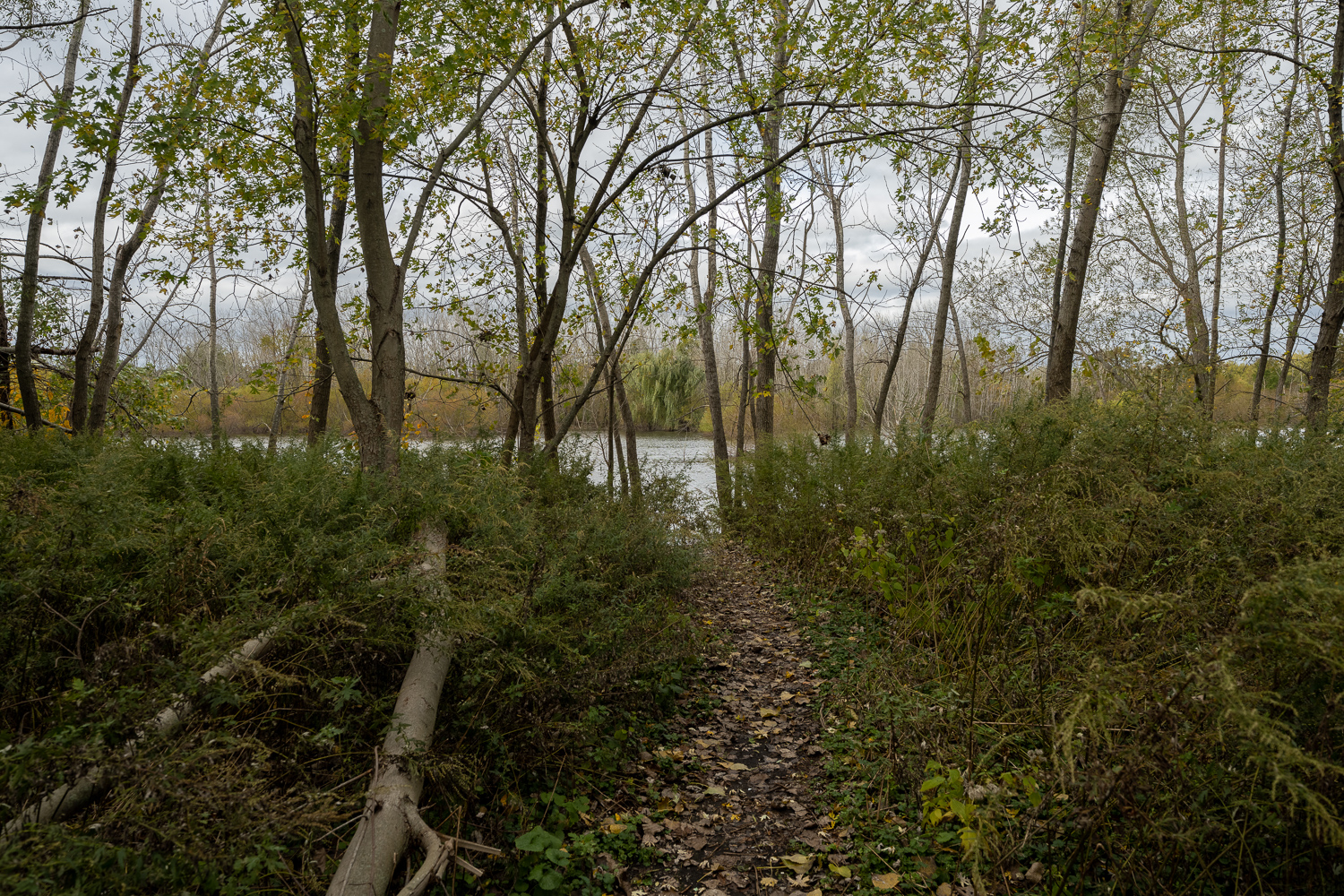
The accompanying set of photographs examines the edge conditions of these swamps, generally impenetrable by foot. People generally treat these boundaries between the civilized and the wild poorly, seeing them as dumping grounds. While I took the photograph of the roadside shrine, the air was punctuated by the rhythmic sound of gunshots. There is a violence to this boundary, filed with detritus, the usual litter, but also spent gunshot shells, car parts, and building debris. The violence of our society washes up against the boundaries of the terrain vague. That the swamplands are impenetrable, untamable is an impossible condition, and results in this sort of violence, rage against the futility of our presence on the planet. But the swamplands of northern New Jersey are also constant reminders of the massive changes that took place in relatively recent geological history and the changes that we are creating as a result of our quest to expand the megalopolis. If, instead of seeing sites like these as sites of potential, sites to be developed, or raging against the impossibility of that promise, we need to reconfigure our vision to see them as sites that have potential as they are, potential not to be developed for human use, but potential for the survival of non-human life on Earth. Leonardo Fiorello, longtime land manager for Wildlife Preserves, Inc., has explained that the swamps they manage are not meant to be sites of recreational opportunities for humans, but rather are for other species. We are not meant to go there.[17] We need to rethink wastelands not as empty but as full, full of nonhuman life and possibility.
[1] Herman Kahn, The Year 2000; A Framework For Speculation On The Next Thirty-Three Years (New York: The Macmillan Company, 1967), 61.
[2] Jean Gottman, Megalopolis. The Urbanized Northeastern Seaboard of the United States. (New York: The Twentieth Century Fund, 1961), 9.
[3] Gottmann, 5.
[4] Ignasi de Solà-Morales Rubió, “Terrain Vague” in Cynthia Davidson, ed, Anyplace (Cambridge MA: The MIT Press, 1995), 118-123.
[5] Solà-Morales Rubió, 120.
[6] Solà-Morales Rubió, 120.
[7] Solà-Morales Rubió, 124.
[8] Jack Flam, ed., Robert Smithson: The Collected Writings. (Berkeley: University of California Press, 1996), 7-9, 68-74.
[9] Paul J. Crutzen and Eugene F. Stoermer, “The Anthropocene,” Global Change Newsletter 41, 17-18.
[10] Mary Bruno, An American River: From Paradise to Superfund, Afloat on New Jersey’s Passaic (Vashon, WA: DeWitt Press, 2012), 225.
[11] Henry Barnard Kümmel’s doctoral dissertation, Lake Passaic: An Extinct Glacial Lake (Trenton NJ: John L. Murphy Publishers, 1895) remains largely accurate and is a good source of information. A more recent discussion is in Stanford, Scott D. “Glacial Lake Passaic.” Unearthing New Jersey, Vol. 3, No. 2. New Jersey Geological Survey – Dept. of Environmental Protection, 2007. https://www.nj.gov/dep/njgs/enviroed/newsletter/v3n2.pdf
[12] Cam Cavanaugh, Saving the Great Swamp: The People, the Power Brokers, and an Urban Wilderness (New York: Vanguard Press, 1978), 39-41 and Leonardo A. Fiorello, A Place Called Whippany. The History and Contemporary Times of Hannover Township, N. J. (Whippany NJ: Len Sunchild Publishing, 2006), 6-15, 42.
[13] Cavanaugh, 23-25.
[14] Bruno, 149-157. This can be read online at https://www.wildlifepreserves.org/interview-wildlife-preserves-founder-robert-l-perkins-jr-and-land-manager-leonardo-fariello.
[15] Steven Mufson, Chris Mooney, Juliet Eilperin, and John Muyskens, 2°C: “Beyond the Limit. Extreme Climate Change has Arrived in America,” The Washington Post, August 13, 2019, https://www.washingtonpost.com/graphics/2019/national/climate-environment/climate-change-america/
[16] United States Environmental Protection Agency, “Why are Wetlands Important,” https://www.epa.gov/wetlands/why-are-wetlands-important
[17] Bruno, 156-157. Also at https://www.wildlifepreserves.org/interview-wildlife-preserves-founder-robert-l-perkins-jr-and-land-manager-leonardo-fariello